-
NTIA launched a public permitting tool to help ISPs identify the permits they’ll need
-
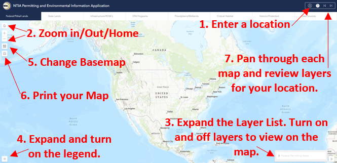
The tool is a map that displays data on federal land, state land, rights of way and tribal lands.
-
Permitting is one of the biggest pain points for ISPs, especially as they get ready for BEAD
Looks like NTIA is trying to lift the weight off permitting for ISPs.
The agency unveiled on Friday a new, publicly available permitting tool to help federal broadband grant recipients and subgrantees identify and understand the types of permits they’ll need and avoid potential environmental impacts.
Dubbed the NTIA Permitting and Environmental Information Application (sounds straightforward enough, right?), the tool is a map that combines public federal maps from agencies such as the Environmental Protection Agency, National Park Service, U.S. Forest Service and other sources.

At a glance, the map looks a lot like the FCC’s national broadband coverage map. But instead of providing data on broadband serviceable locations, NTIA’s map shows you which federal lands belong to which agency. It also displays rights of way, state lands data and tribal lands boundaries.
Users can either print the map showing the data they need or transfer the data to their geographic information systems (GIS). NTIA said in the coming weeks it will announce “additional permitting initiatives to support federal broadband deployment projects.”
The permitting help just keeps on coming. Earlier this month, the Advisory Council on Historic Preservation announced an amendment that aims to make the broadband permitting process easier for federal agencies.
And it makes sense, given the complaints from broadband providers. At the ACA Connects Summit earlier this month, Metronet CEO summed up deployment struggles as “the three Ps: paint, poles and permitting.”
For NTIA’s part, it’s trying to get permitting squared away before states begin awarding grants to ISPs as part of the Broadband Equity, Access and Deployment (BEAD) program.
But BEAD money will likely start flowing later than originally expected, according to New Street Research (NSR), as states must first tackle their respective mapping challenges and grant processes.
NTIA must also finish reviewing state BEAD plans (i.e., the initial proposals). However, the agency “does not have a fixed deadline for when it must complete the work,” said NSR’s Blair Levin in a note to investors.
“Based on what we heard, we think it is unlikely for any significant number of BEAD funded networks to be operational in 2025, with 2026-2028 being the window for when most become operational,” Levin said.
