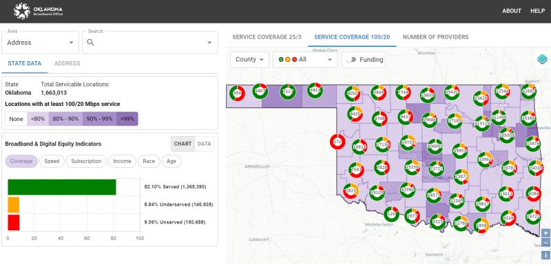
Oklahoma’s broadband office has released a new interactive online map detailing internet connectivity across the state – a tool to help prepare its Broadband Equity, Access and Deployment (BEAD) plans.
The map breaks down the state’s served, underserved and unserved locations into color-coded categories of green, yellow and red, respectively. Served addresses are those with broadband service at or above 100 Mbps downstream and 20 Mbps upstream, which is also the minimum speed requirement for BEAD funded projects.
Underserved locations have speeds less than 100/20 Mbps but above 25/3 Mbps, while unserved addresses don’t have any broadband service above the 25/3 threshold. You can view the map with all served, underserved and underserved addresses or filter through each category individually.

The map, designed in partnership with the Sanborn Map Company, indicates a largest number of unserved addresses are in the eastern part of the state, such as in Latimer and Osage counties.
Whereas underserved locations are concentrated in northeastern and central Oklahoma – Logan and Rogers counties, for instance.
Other features include reported internet speeds by location, the ability to view service availability within congressional and state legislative districts as well as a filter highlighting which locations are covered by federal funding programs, like the ReConnect Program and the Rural Digital Opportunity Fund (RDOF).
“We are proud to support the Oklahoma Broadband Office at this critical moment,” said Sanborn Senior Project Manager Brian Coolidge in a statement. “The new online Oklahoma map will help the Oklahoma Broadband Office to share critical information with the public, internet service providers, and other stakeholders.”
The White House at the end of June unveiled each state’s BEAD allocation, with Oklahoma poised to get approximately $797.4 million. Each state needs to submit an initial proposal describing how it plans to run its BEAD grant programs by the end of the year.
Some states plan to release those proposals for public comment sooner rather than later, such as Missouri. States are also in different stages of the mapping process.
Kentucky broadband director Meghan Sandfoss told Fierce in March the state did not have its own broadband map (which as of this writing is now available to view). Whereas in Nebraska, bureaucratic roadblocks hinder the state map’s development.
